[颱風] 01C 艾歐娜 中太連續兩年破蛋
風場+結構達標 緊急命名
https://i.meee.com.tw/7LQ5isZ.png
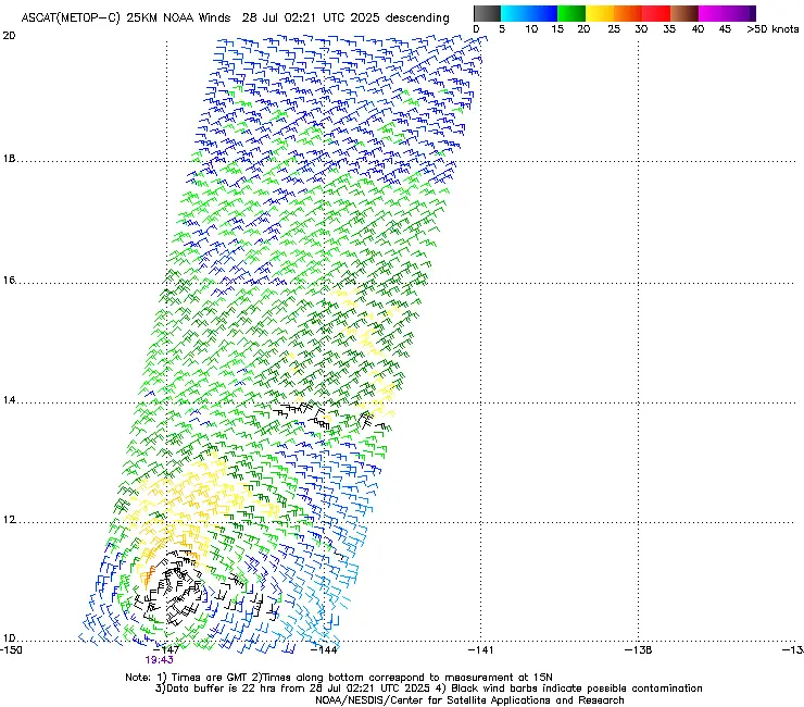
MXWD=32.4KTS
【升格報+預測資料】
655
WTPA41 PHFO 280231
TCDCP1
Tropical Storm Iona Discussion Number 4
NWS Central Pacific Hurricane Center Honolulu HI CP012025
Issued by NWS National Hurricane Center Miami FL
500 PM HST Sun Jul 27 2025
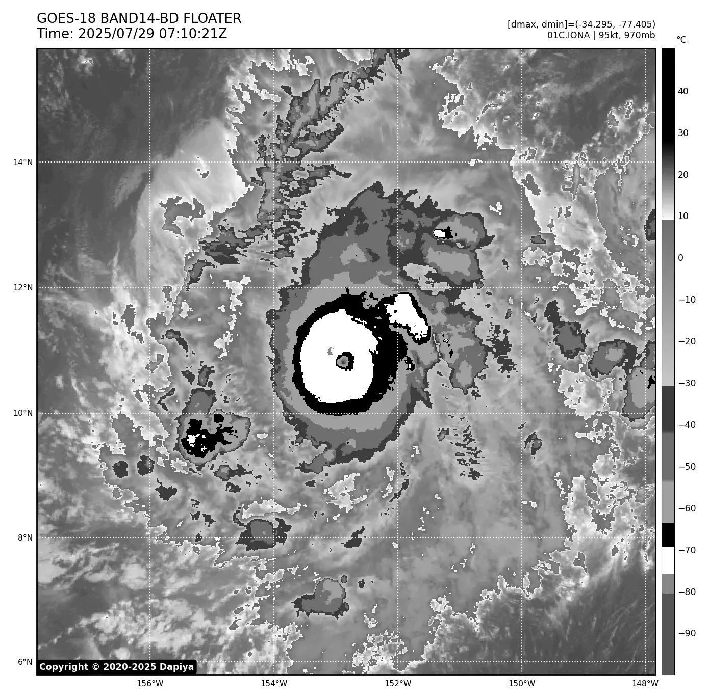
A strong burst of deep convection with very cold cloud tops below
-80C developed over the low-level center of the tropical cyclone
well southeast of the Hawaiian Islands earlier this morning into the
early afternoon. This activity has recently subsided, but the
satellite presentation has improved since the previous advisory,
with well-defined banding structures now evident. The latest
subjective Dvorak intensity estimates from PHFO, SAB, and JTWC all
came in at 2.5/35 knots, while the objective intensity estimates
ranged from 35 to 42 knots. Taking a blend of these data, the
initial intensity for this advisory has been raised to, perhaps a
conservative 35 knots, making Iona the first named storm of the
season in the central Pacific.
Tropical Storm Iona is moving westward at 270/9 knots. This general
westward motion is expected to continue during the next couple of
days as the system moves along the southern periphery of a
subtropical ridge to the north. By Tuesday night or Wednesday, Iona
is expected to increase its forward speed due to a strengthening
low-to-mid-level ridge north of the system. The track forecast
closely follows a blend of the FSSE and HCCA consensus guidance and
is very close to the track from the previous advisory. Confidence
remains high that Iona will stay well to the south of the Hawaiian
Islands.
The environment appears conducive to further intensification over
the next day or so, as Iona remains over warm waters around 28C,
with adequate mid-level moisture and very light vertical wind shear.
As a result, the intensity forecast calls for steady strengthening,
with the cyclone expected to near hurricane strength by Monday night
or Tuesday. However, by Tuesday night, Iona will begin to move over
slightly cooler waters, begin to feel the influence of increasing
westerly vertical wind shear, and start to entrain drier mid-level
air. This is expected to result in steady weakening, with the
cyclone likely becoming a post-tropical remnant low by Day 5 and
potentially weakening into a trough by that time. The intensity
forecast has been raised from the previous advisory, following the
latest trends in the intensity guidance, and is best aligned with
the FSSE and HCCA consensus guidance.
FORECAST POSITIONS AND MAX WINDS
INIT 28/0300Z 10.9N 148.3W 35 KT 40 MPH
12H 28/1200Z 11.0N 149.7W 45 KT 50 MPH
24H 29/0000Z 11.0N 151.7W 55 KT 65 MPH
36H 29/1200Z 11.0N 153.8W 60 KT 70 MPH
48H 30/0000Z 11.1N 156.4W 60 KT 70 MPH
60H 30/1200Z 11.5N 159.4W 50 KT 60 MPH
72H 31/0000Z 12.1N 162.9W 45 KT 50 MPH
96H 01/0000Z 13.0N 170.4W 35 KT 40 MPH
120H 02/0000Z 14.4N 177.4W 30 KT 35 MPH...POST-TROP/REMNT LOW
$$
Forecaster Jelsema (CPHC)
https://i.meee.com.tw/pGIfNFR.png
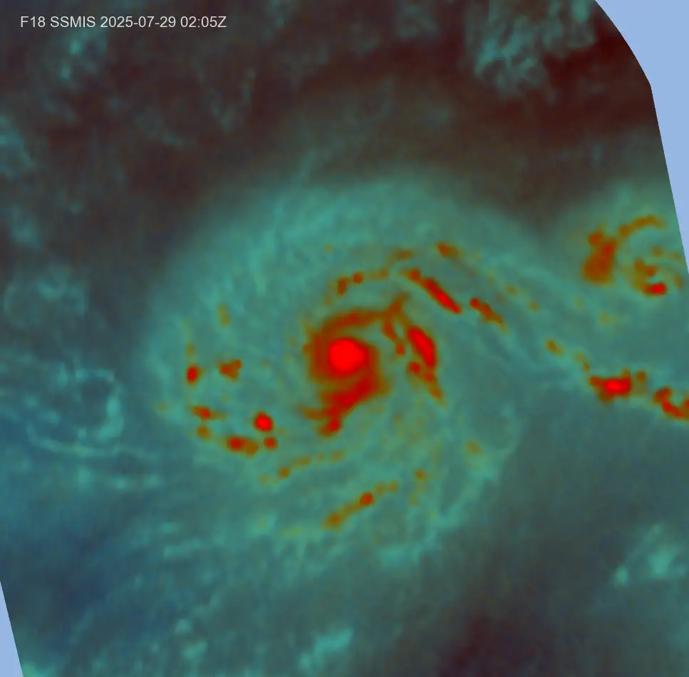
【衛星定位分析】
--
TXPN41 PHFO 272340
TCSNP1
CENTRAL PACIFIC TROPICAL CYCLONE SUMMARY - FIXES
NWS CENTRAL PACIFIC HURRICANE CENTER HONOLULU HI
2330 UTC SUN JUL 27 2025
A. TROPICAL DEPRESSION ONE-C CP012025
B. 27/2330Z
C. 11.0N
D. 147.8W
E. GOES-18
F. T2.5/2.5/D1.0/24 HRS
G. VIS/IR/EIR
H. REMARKS...0.45 WRAP ON LOG10 SPIRAL YIELDS A DT OF 2.5. PT AND
MET AGREE AT 2.5. FT BASED ON DT.
I. ADDL POSITIONS
$$
KINO
--
TPPZ01 PGTW 272358
A. TROPICAL DEPRESSION 01C (SE OF HILO)
B. 27/2300Z
C. 10.89N
D. 147.72W
E. SIX/GOES18
F. T2.5/2.5/D1.5/21HRS STT: D0.5/03HRS
G. IR/EIR/VIS/MSI
H. REMARKS: 44A/PBO LARGE CDO/ANMTN. IRREGULAR CDO OF 85NM IN
DIAMETER YIELDS A CF OF 2.0. ADDED 0.5 FOR BF TO YIELD A DT OF 2.5.
MET YIELDS 1.5. PT YIELDS 2.5. DBO DT.
I. ADDITIONAL POSITIONS: NONE
NEVAREZ
--
TXPN26 KNES 280025
TCSCNP
A. 01C (NONAME)
B. 28/0000Z
C. 11.0N
D. 147.7W
E. THREE/GOES-W
F. T2.5/2.5
G. IR/EIR/VIS
H. REMARKS...4/10 BANDING YIELDS A DT OF 2.5. THE MET IS 2.0. THE PT
IS 2.5. THE FT IS BASED ON THE DT.
I. ADDL POSITIONS
NIL
...GATLING
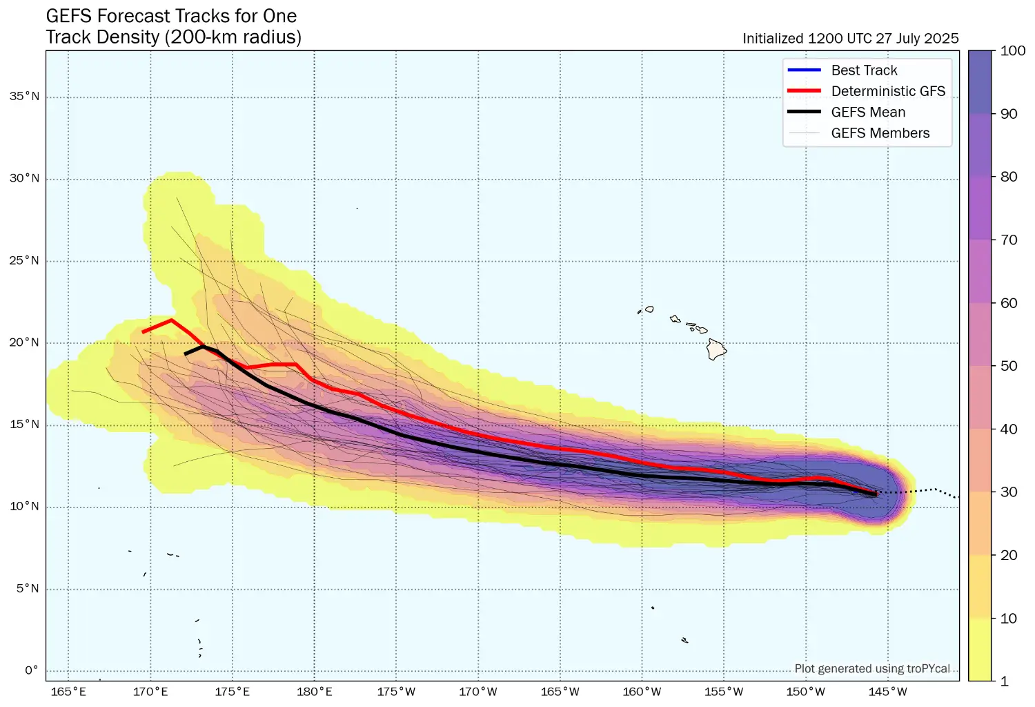
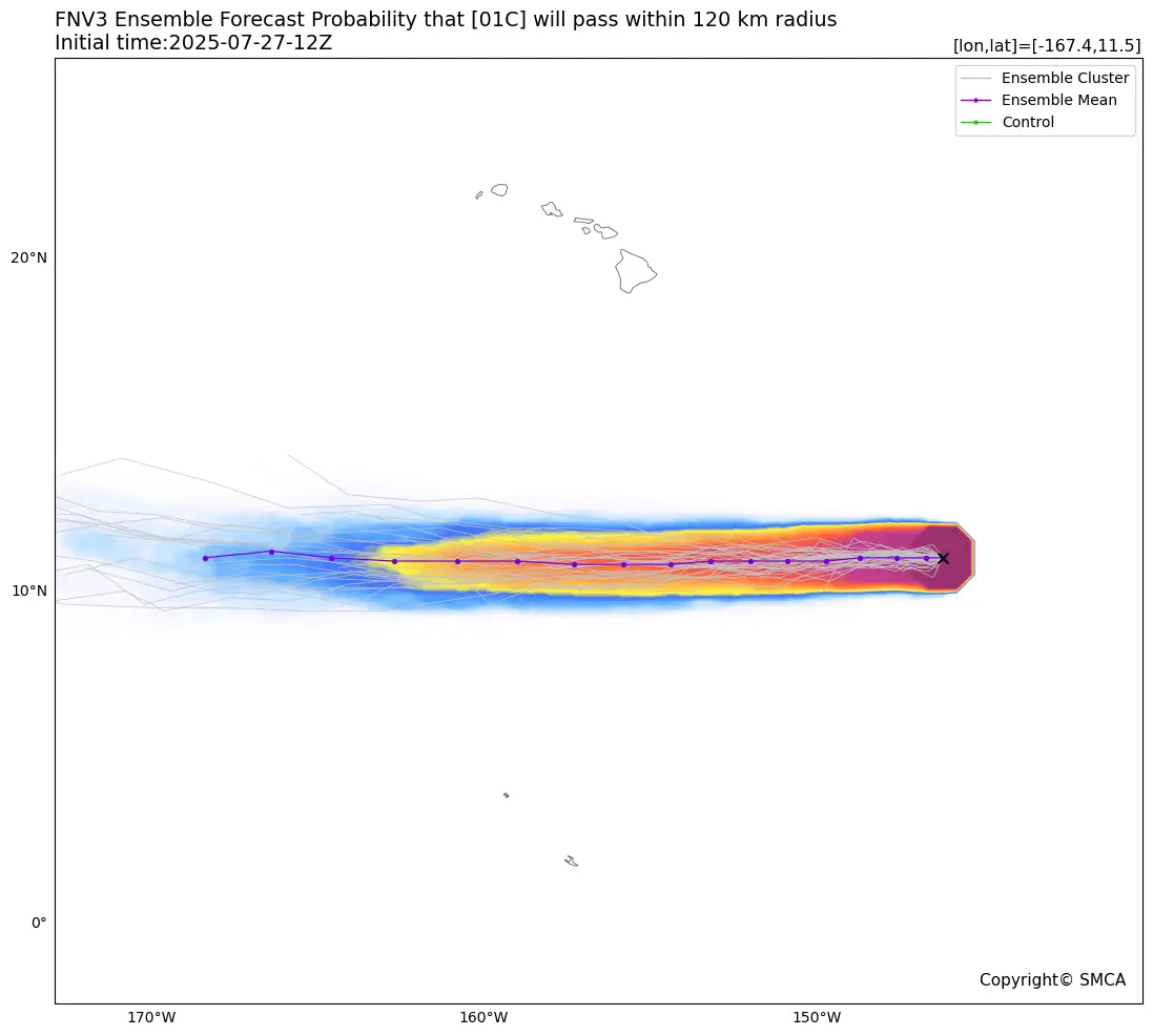
【系集路徑預報】
--
GFS
https://i.meee.com.tw/2OYMtNl.png
--
※ 發信站: 批踢踢實業坊(ptt.cc), 來自: 220.133.216.116 (臺灣)
※ 文章網址: https://www.ptt.cc/bbs/TY_Research/M.1753670057.A.6F5.html
※ 編輯: kadar (220.133.216.116 臺灣), 07/28/2025 10:43:32
推
07/28 10:39,
4月前
, 1F
07/28 10:39, 1F
→
07/28 10:44,
4月前
, 2F
07/28 10:44, 2F
※ 編輯: kadar (220.133.216.116 臺灣), 07/28/2025 10:50:31
推
07/28 22:58,
4月前
, 3F
07/28 22:58, 3F
推
07/29 12:13,
4月前
, 4F
07/29 12:13, 4F
推
07/29 15:32,
4月前
, 5F
07/29 15:32, 5F
→
07/29 15:32,
4月前
, 6F
07/29 15:32, 6F
推
07/29 15:32,
4月前
, 7F
07/29 15:32, 7F
推
07/29 22:17,
4月前
, 8F
07/29 22:17, 8F

→
07/29 22:18,
4月前
, 9F
07/29 22:18, 9F
推
07/29 22:32,
4月前
, 10F
07/29 22:32, 10F
→
07/30 07:48,
4月前
, 11F
07/30 07:48, 11F